one and a half million people live in the Galilee, each one for their own special reason. Some like the wide open spaces, the green fields and the bright blue skies. Some like the sounds of nature – the wind blowing through the trees, the rush of water in the brooks and riverbeds, and some like the diverse population – a tapestry of religions, communities unparalled anywhere else in Israel.
Others like the magic and mystery of the Galilean sages and rabbis, the pilgrimage sites and tombs to pray at, and of course there are others who like the tasty culinary world of the Galilee, from the fruits to the crystal clear water.
This Galilee guide combines all of the above with the unique charateristics of Galilee.
The ERETZ Guide to Galilee includes 12 routes each one detailed by a different guide or expert with their own unique and different style, with insights that he or she would share with the traveler.
The routes in this guide are not the usual travel itinerary. They are ideas to be followed, highlights to pass by, or maybe stop for the view, the air, or the natural heritage.
And, if you detour from the route, as your own personal curiosity, or a whim, takes you, this guide has fulfilled its purpose.
Hadar Gatt and Yadin Roman
The North Shore
Between Rosh Hanikra and Nahariya
By Yadin Roman
The shore between Rosh Hanikra and Nahariya is one of the most beautiful stretches of beach along the coast of Israel. Unlike the straight coastline of sandy beaches to the south, there are little inlets and coves, a cliff plunging into the sea, and even six small islands opposite the shoreline.
Half a century ago, I was a member of a Nahal group slated for Kibbutz Rosh Hanikra. For nearly a year, our group lived in a row of shacks on the Ladder of Tyre slope, the range that separates Israel from Lebanon. We worked in the fields from the early morning hours, spending the afternoons exploring Israel’s northern shore next to the kibbutz.
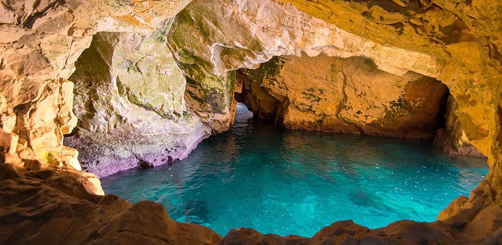
The construction of a cable car to the sea grottos at the foot of the white chalk cliffs of Rosh Hanikra was still a few years away; the only way to get into the grottos was to swim. Riding the swell of the waves, we made our way into these towering sea canyons and explored the dozens of cracks in the rock, eroded by the sea into underground caves and hidden caverns. South of the caverns, we snorkeled in the small inlets between the abrasion platforms along the shore, among the multi-colored fish, and a sea turtle or two. At the same time, beneath us, on the clear sandy seafloor, sea cucumbers and stingrays made their way through forests of green seaweed.
The obvious start for a North Shore tour is Rosh Hanikra, the western outcrop of the prominent Ladder of Tyre (Sulam Tzur). In 1924, British and French officers marked the border between British Palestine and French Syria, the first border in the dismembered Ottoman Empire, where borders were unknown. Cairns placed along the ridge’s crest, later replaced with numbered stone pillars, marked the boundary. Border marker number 1 still stands at the Rosh Hanikra border crossing, which today only serves the United Nations peacekeeping force. The British Mandate customs house still stands at the border crossing, next to the radar station built in the 1940s to spot boats of Jewish immigrants trying to get into Palestine.
An observation platform, restaurant, and the cable car’s upper station down to the grottos can be found near the border crossing. The white cliff face of Rosh Hanikra is marred with cracks and openings created by the contact between rainwater and the chalky rock. Over the years, the rain has enlarged the cracks and created an underground drainage system through which the rainwater enters the sea. Once the caves in the rock reach sea level, the waves enlarge and form the grottos that we can visit today. These are not the only sea caverns on the Ladder of Tyre. There are more on the Lebanese side of the border.
Until World War II, the only way to cross from Lebanon to Palestine along the coast was to climb the Ladder of Tyre. Following the conquest of Lebanon from Vichy France in World War II, the British decided to connect the Palestine and Egypt rail network with the Lebanon network by extending the line from Haifa to Beirut and from there through Tripoli to Istanbul and Europe. The British Army deployed engineering units from South Africa, Australia, and New Zealand to construct the line. To get over the Ladder of Tyre, the engineers dug two tunnels through the Rosh Hanikra cliff above the caverns. A bridge over the northern grotto connected the two tunnels. The tunnels were completed in April 1942, and the whole line was completed by the end of the year.
The Haifa-Beirut line never came into regular service and was only used during the war for military purposes. On March 14, 1948, during the Night of the Bridges operation, when all the bridges connecting Palestine to the lands around them were destroyed by the Haganah, the Carmeli brigade blew up the bridge connecting the two tunnels. After the War of Independence, the exit from the northern tunnel into Lebanon was blocked.
Today a cable car leads down the cliff to the caverns. In the northern train tunnel, a multi-media presentation tells the story of the caverns and the train tunnels. A tunnel dug through the cliff leads through the two largest caverns, exiting opposite the Elephant’s Foot, a large sea arch south of the ridge. From there, a path continues around the cliff back to the lower cable car station.