The Great Rebellion of the Jews against the Romans was not pre-planned. It started with a not-too-extraordinary riot in Jerusalem during Passover in 66 CE. During the Jewish pilgrimage festivals, the Romans stationed military forces in Jerusalem to control the crowds. But this time, when Roman soldiers tried to steal from the treasures of the Temple, violent riots broke out. The procurator, Gessius Florus, had to retreat with his forces to the safety of Herod’s palace. The Jews quickly took control of the Temple Mount and bottled up the procurator and his forces in the palace. King Agrippa, upon hearing of the riots, hurried to the city in order to try to convince the people that fighting Rome was of no avail. But as he was trying to placate the Jerusalemites, a group of Sicarii, led by Menahem of Gamla, managed to overcome the Roman garrison in Masada, take possession of the large quantities of weapons stored there, and hurry to Jerusalem with the weapons. While the Sicarii were on their way, local anti-Roman priests stopped the daily sacrifices for the well-being of the emperor. The rebellion against Rome was now official. Once Menahem and his Sicarii arrived in the city, the palaces of the high priest, of Agrippa, and of his sister Bernice were torched, together with the city archive that contained all records of debts and loans. The Roman garrison, still holding out in the Antonia Fortress that overlooked the great Temple platform, was attacked. After two days of fighting, the fortress fell and the remainder of the Roman defenders retreated to Herod’s palace. The Roman soldiers agreed to put down their weapons in return for safe conduct out of the city, but once they allowed the rebels into the palace, they were all slaughtered. The rebellion spread throughout the country. In the cities with both Jewish and pagan communities, riots broke out between Jews, Samaritans, and Pagans. When it became clear that the local Roman forces could not restore order, Cestius Gallus, the governor of Syria, set out for Judea at the head of the Twelfth Roman Legion and auxiliary forces. After restoring a semblance of order along the coast, he arrived in Jerusalem during the Feast of Tabernacles. When he failed to break into the city, he decided, for no apparent reason, to retreat – which turned his entire military campaign into a fiasco. The Jews pursued the retreating Romans and attacked as the legion made its way down to the coastal plain. Some 6,000 Roman legionnaires fell in the battle and the rebels gained a supply of armor, weapons, and military equipment. The victory united all the factions of the Jewish population. A provisional government was set up and governors were sent to different parts of the country. Jerusalem was put under the command of Joseph, son of Gorion, and the high priest, Hanan; Edom was given to Joshua, son of Sapphias and the priest Elazar ben Hanania. Joseph, son of Matityahu, the future historian Josephus Flavius, was put in charge of the Galilee. In the spring of 67 CE, Nero put his most seasoned general, Vespasian, at the head of the 60,000-man military force that would be sent to Judea to suppress the rebellion. Vespasian started his offense by landing, unhindered, in Acre. Marching into the Galilee, he first came upon Sepphoris, which from the start had leaned towards the Romans, and took control of the town. From the outset, the Jewish forces had no chance against the might of Rome – their only hope was to ambush the Romans as they marched and to try to hold out in fortified cities against the legionnaires. To do so an experienced and united military command was needed – Josephus was no military commander. Yodefat, the stronghold that he personally commanded, held out for a few months of bitter fighting, but finally succumbed in the summer of 67 CE. Josephus turned himself over to the Romans and became the official Roman historian of the war, writing under the name Josephus Flavius – the family name of Vespasian. After Yodefat’s fall, Tiberias surrendered to the Romans. The neighboring town of Trichea (Magdala), resisted. When the town fell, the defenders continued fighting from boats on the Sea of Galilee until the Romans built a fleet and put an end to the last source of resistance around the lake. Gamla, the stronghold of the Sicarii on the Golan Heights, was then put under siege. After a bitter battle, the Romans managed to make their way into the hilltop town. The surviving defenders gathered at the top of the cliff around which the town was built, and jumped to their deaths. The Romans then moved on to Tabor and Giscala (Gush Halav) in the Upper Galilee. Gush Halav was the hometown of John of Giscala, Josephus’s old rival for the leadership in the Galilee. By this point, however, John had moved on to Jerusalem to organize the defense of the capital. The debacle in the Galilee prompted an outbreak of violence in Jerusalem, with the extremists accusing the more moderate factions, mainly composed of the priests and the wealthy, of not wholeheartedly supporting the rebellion and secretly harboring the desire to surrender to the Romans. Civil war broke out in the city. Vespasian let his armies rest during the winter and continued the conquest of the rest of the land in the spring of 68 CE. He split his forces in order to execute a pincer maneuver, sending one force to make its way along the coast and the other to proceed via the Jordan Valley. By the end of 68 CE, the only territories still under rebel control were Jerusalem and the Judean Desert. Meanwhile, despite the imminent approach of the Roman legions, the civil war in Jerusalem continued. During the year spanning 68 and 69 CE, dramatic events unfolded in Rome. Nero died and four different emperors ascended the throne in the year after his death. The fourth was Vespasian, nominated to the throne by his troops. Vespasian left the conduct of the war in Judea to his son Titus. The Jewish forces did not take advantage of this year of inactivity to organize the defense of Jerusalem. The leaders of the three main Jewish factions – John of Giscala, Eleazar ben Simon, and Simon bar Giora – continued fighting among themselves, each one controlling a different part of the city. The battle of Jerusalem started in the summer of 70 CE, when Titus besieged the city for five months. When the Jews managed to destroy the Roman ramps and siege engines, Titus decided to starve the city and surrounded it with a siege wall. In August, the Romans managed to capture the great Antonia Fortress. After the fall of the fortress, they conquered and set fire to the Temple. The upper city held out for another month, but it was clear that the battle was over. The city was set ablaze and Jerusalem was destroyed. Herod’s magnificent Temple was no more. Two fortresses south of Jerusalem still remained in the hands of the rebels: Machaerus, on the eastern side of the Dead Sea; and Masada, on the western side. Three years after the rebellion, in 72 or 73 CE, the Romans stamped out this last bastion of resistance.
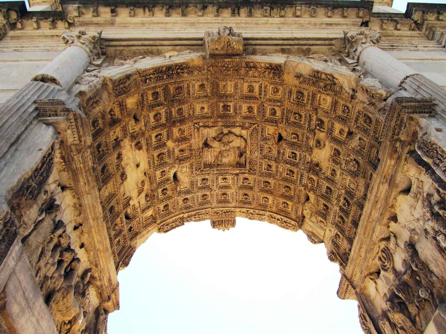
The oldest-known depiction of the menorah and the sacred vessels from the Second Temple in Jerusalem appear on one of the bas-reliefs adorning the Arch of Titus in the Roman Forum. This arch was erected in the first century CE to commemorate Titus’s conquest and destruction of Jerusalem and the Temple. This past spring, a second Arch of Titus was discovered in Rome. This one stood in the Circus Maximus stadium and it too commemorates the conquest of Jerusalem. This discovery, along with recently completed research confirming that the menorah in the bas-relief originally was painted a golden yellow to emphasize that it had been crafted from pure gold, sheds new light on this distinctive architectural element. > by Yadin Roman
The eve of Hanukka on December 23, 1997, was clear and starry in Rome. A group of people was gathered in the Roman Forum next to the Arch of Titus, which stands on the Via Sacra leading to the Temple of Jupiter on Capitoline Hill. Roman emperor Domitian is credited with erecting this arch in 81 CE to commemorate the deification of his brother Titus and his conquest and destruction of Jerusalem. For hundreds of years, perhaps even since the arch was completed, the rabbis of the Jewish community in Roman strictly forbade their followers from walking under the arch. Anyone who violated this ban was considered to have left Judaism and his or her soul was cut off from the Jewish people. The group that gathered by the arch on the eve of Hanukka in 1997 included then-Italian prime minister Romano Prodi, then-mayor of Rome Francesco Rutelli, Italian dignitaries, the rabbis of Rome, and the city’s entire Jewish community. In an impressive, joyous ceremony full of light, the ban on walking under the arch was formally revoked in honor of the fiftieth anniversary of the establishment of the State of Israel. The time has come to remember the tragedy of the Holocaust and reaffirm the right of all people to live in peace and dignity in all places, the Italian prime minister declared in his speech at the ceremony. “When many people look at the sculpture under the arch,” the mayor said, “they only see the misery inflicted upon a conquered race. But look again. I see not a conquered race, but a monument to one of the greatest modern nations on earth. The conquering Romans are a footnote of history, but the Jewish nation continues to thrive, within and outside the State of Israel. That is what the arch represents to me.” After the ceremony, some Roman Jews peeked at the reliefs, which are located on the underside of the arch, but could not bring themselves to actually walk through it. The Arch of Titus is one of the 36 triumphal arches that stood in Rome in the fourth century CE, before the glory of the empire that the city’s sons had established faded. Only three of these arches still are standing today: the Arch of Titus; the Arch of Septimius Severus, which was erected in 203-205 CE; and the Arch of Constantine, which was constructed in 312 CE. The Roman triumphal arch is one of the innovations that the Romans gave to the world of architecture. Triumphal gates had been known for thousands of years before the days of Rome. Hittite, Assyrian, and Babylonian kings would boast of their victories by building monuments adorned with inscriptions and depictions relating the story of their triumphs. The Etruscans, the ancient tribe that the Romans conquered at the beginning of their rise, would erect such monuments at the entrances to their cities or on central streets as stand-alone elements not connected to a wall or a building. The Roman triumphal arch was a distinctive development because it brought together two elements that had never been seen together before: a round arch mounted on two columns or piers and a large square assemblage on top of it. These two elements had been used separately in the ancient world for hundreds of years. Arches appeared in canals and water drainage systems and as an engineering element to lower the pressure on openings in a wall such as windows and entranceways. The upper structure of the arch, a beam that connects two columns, could be seen in Greek temples as part of the system that held up the roof and provided a place for reliefs and decorations. Sculptures of gods or of the emperor were installed above the Roman triumphal arch. The sculptures on the Arch of Titus in the Roman Forum disappeared over the ages, but examples of this can be seen in the 40 odd triumphal arches erected in the world’s capitals, almost all of which were inspired by the Arch of Titus. They include the Arc de Triomphe in Paris; the Brandenburg Gate in Berlin; the triumphal arches in Saint Petersburg, Moscow, New York, London, New Delhi, and Brussels; as well as the arches in numerous other countries, such as Hungary, Italy, Iraq, Laos, Macedonia, the Philippines, Portugal, Romania, and Australia, to name a few. The first Roman triumphal arches were erected in the days of the republic by leaders and military commanders who saved the city or presided over important victories. They built monuments to commemorate their valor themselves. However, when the republic became an empire, emperor Augustus ordered that triumphal arches only be built for emperors – and only after the Senate had approved the convening of a triumphal march, known as a triumph, for them. The triumphal arch thus transformed from a personal symbol to a tool of governmental rule. Rome built imperial arches in public places, such as on main roads, at squares, at the entrances to stadiums, and so on. The goal was for the public to pass through the arch and be impressed by the message that this public monument was intended to convey. The Triumph Titus Flavius Caesar rose to power on June 23, 79 CE, following the death of his father, emperor Vespasian. In 67 CE, 13 years earlier, emperor Nero had sent Vespasian to the province of Judea to quell the Jews’ revolt. At the time, Vespasian, then 57, already had retired from public life. He had distinguished himself in his youth as a military commander fighting in Germany and participating in the invasion of England. In 63 CE, Vespasian was appointed governor of Africa. After completing his term in Africa, he returned to Rome. Vespasian was not from a wealthy family; his weak financial position after retiring from public office forced him to earn a living by trading in mules, but his business dealings were unsuccessful. Meanwhile, he was invited to join Nero’s entourage on a trip to Greece. During the visit, Vespasian was caught dozing at one of the mad emperor’s theater or musical performances and was forced to flee for his life. After the revolt broke out in Judea, and the Jewish rebels defeated the Roman governor in Syria, Nero summoned the disgraced Vespasian to duty, handing him command of the legions in the east. Nero did not choose Vespasian by chance: a military commander who was not a member of the Roman nobility was not considered a threat to the emperor. Vespasian had his oldest son, Titus, join his forces. Two years after the rebellion broke out, in 68 CE, Nero committed suicide. The empire deteriorated during a series of power struggles in a period that became known as the Year of the Four Emperors. The first to take power were the commanders of the western legions. When they did not succeed to stabilize the empire – and were murdered, one after the other – the legions in Alexandria declared Vespasian the new emperor. The legions of the east quickly joined them. Vitellius, the last of the three emperors who preceded Vespasian, was murdered and Vespasian was named emperor on July 1, 69 CE. The new emperor left his son Titus in Judea to finish the war against the Jews. During 70 CE, Titus conquered the Jordan Valley and the approach to Jericho and the Dead Sea and then set siege to Jerusalem. After a five-month siege, and the death of thousands of the city’s residents in battle and from starvation, Jerusalem fell. The Roman legions slaughtered or enslaved the surviving Jerusalemites, demolished the city’s buildings, and destroyed the magnificent Second Temple that Herod had built. Titus returned to Rome a hero, accompanied by his Jewish mistress, Bernice, the daughter of king Agrippa I and the great-granddaughter of Herod and Mariamne the Hasmonean, and Josephus Flavius, who was appointed the imperial court historian. The city honored Vespasian and Titus for the victory in Judea with a grand triumph: a procession of the legions and thousands of Jewish captives as well as a display of the great treasures plundered in the war, including the sacred Temple vessels. At the end of the victory procession, Simeon Bar Giora, who the Romans had identified as the military commander of the rebellion, was executed. Josephus provides a detailed description of the triumph in his book, The Jewish War (Book VII, 132-162, from H. St. J. Thackeray’s translation from the Greek, Loeb Classical Library, 2004). “It is impossible adequately to describe the multitude of those spectacles and their magnificence under every conceivable aspect,” Josephus writes before offering a survey of the wealth of gold, silver, and ivory vessels, tapestries dyed with the rare purple dye, precious stones, and sculptures. The procession also included many species of animals and multitudes of finely dressed people, including the captives, Josephus continues, noting, “the variety and beauty of their dresses concealing from view any unsightliness arising from bodily disfigurement.” Soldiers carried huge mobile stages depicting the story of the war in which “a prosperous country was devastated, … also every place full of slaughter…. The spoils in general were borne in promiscuous heaps; but conspicuous above all stood out those captured in the temple at Jerusalem. These consisted of a golden table, many talents in weight, and a lampstead [the menorah], likewise made of gold, but constructed on a different pattern from those which we use in ordinary life. Affixed to a pedestal was a central shaft, from which there extended slender branches, arranged trident-fashion, a wrought lamp being attached to the extremity of each branch; of these there were seven, indicating the honour paid to that number among the Jews. After these, and last of the spoils, was carried a copy the Jewish Law [a Torah scroll]…. “The triumphal procession ended at the temple of Jupiter Capitolinus, on reaching which they halted; for it was a time-honoured custom to wait there until the execution of the enemy’s general was announced. This was Simon, son of Gioras, who had just figured in the pageant among the prisoners, and then, with a halter thrown over him and scourged meanwhile by his conductors, had been hauled to the spot abutting on the Forum, where Roman law requires that malefactors condemned to death should be executed. After the announcement that Simon was no more and the shouts of universal applause which greeted it, the princes [Vespasian and Titus] began the sacrifices, which having been duly offered with the customary prayers, they withdrew to the palace.” After the triumphal festivities ended, Vespasian built a temple to peace and “Here, too, he laid up the vessels of gold from the temple of the Jews, on which he prided himself; but their Law [Torah scroll] and the purple hangings of the sanctuary he ordered to be deposited and kept in the palace.” Vespasian used the extensive spoils from the Second Temple to finance building the grand Colosseum stadium. When he died in 79 CE, Titus succeeded him; this was the first time in the Roman empire that a son succeeded his father. Titus ruled for only two years, during which he faithfully dealt with the victims of the eruption of the volcano of Mount Vesuvius in 79 CE, the great fire that broke out in Rome in 80 CE, and the victims of the plague that swept his empire. He also completed the construction of the Colosseum before his death in September 81 CE. Domitian, the brother of Titus, succeeded him. Today it is commonly accepted that he erected the Arch of Titus in the Roman Forum shortly after his brother’s death. The arch commemorates the deification of Titus – something which happens after his death – and so the accepted explanation is that Domitian built it to reinforce his connection to the acts of valor performed by his father and brother, acts that won him the throne. The Temple Menorah The Arch of Titus in the Roman Forum has a monumental inscription on its facade: “The Senate and the People of Rome to the late divine Titus Vespasian, Augustus, son of the late divine Vespasian.” The inscription on the opposite side of the arch was added much later, after the arch was restored in 1882, after having been used for generations as part of the wall surrounding the estate of a wealthy resident of Rome. This inscription describes the restoration work, which was performed at the orders of pope Pius VII. When one walks under the arch and looks up, there is a relief in the center of the underside depicting the deification of Titus. However, the arch’s main significance comes from two other reliefs, which are located high up on the inner sides of the arch. Both of these reliefs depict the triumph to celebrate crushing the rebellion in Judea. One shows Titus riding a chariot harnessed to four white horses with an eagle, the symbol of Roman power, perched on his shoulder. Soldiers are depicted marching alongside the chariot and in front of it are rows of captives. The second relief shows Roman soldiers carrying the sacred vessels of the Temple, with the golden menorah at the center, surrounded by the table of the shew bread, trumpets, and incense shovels. This is the oldest known depiction of the sacred Temple vessels, leading researchers to accept it as an accurate depiction of the menorah that stood in the Second Temple. However, as more and more ancient synagogues were dug up by archaeologists, a different kind of menorah came to light, this time depicted on the mosaic floors of these synagogues from the talmudic period. These mosaic menorahs, which were dated to later periods than the Arch of Titus, were shown standing on three legs, not on a base, as it is shown on the Arch of Titus. A very active debate on the topic has been underway for decades – did the Jewish mosaic floor artists get it wrong? Some claim that the base seen on the menorah in the arch is simply a box that was built around the menorah so that it could be carried easily in the triumph. The latest of the many studies of the menorah on the Arch of Titus was conducted in June 2012 by a team of archaeologists from Yeshivah University in New York, US, working with archaeologists from Rome. They performed high-resolution, three-dimensional scans of the reliefs of the menorah and the deification. One of their most interesting findings was the discovery of traces of yellow ochre on the menorah’s base and arms. It turns out that the menorah was painted a golden yellow, including the base, as befits an item made of pure gold. Who Built the Arch of Titus? There is no doubt that the Arch of Titus was erected in the Roman Forum after the death of Titus. The emperor was deified only after his death and the inscription in the arch refers to “the divine Titus Vespasian” as does the relief in the ceiling of the arch showing the deification of Titus. Many concluded that the other Arch of Titus, the one that had stood at the great Circus Maximus arena, was the one dedicated to Titus during his lifetime. In the Middle Ages, it still was possible to see this arch and an anonymous source who visited ancient Rome preserved the inscription that was carved on it: “The Senate and the People of Rome dedicate this arch to the emperor Titus Caesar, son of the divine Vespasian, Augustus, the high priest, holding authority in the tenth tribune, the seventeenth emperor, the eighth consul, father of the homeland, ruler of the nation, since according to his father’s command and the advice of fate he subdued the Jewish people and destroyed the city of Jerusalem, a city that was assailed in vain before him by military commanders, kings, and nations.” In this inscription, Vespasian is divine, while Titus is the emperor, which could be a hint that the arch was built during the lifetime of Titus and by Titus. Until recently, it was assumed that this arch had been completed destroyed and its stones were looted to be used in other structures. However, this year, the base of an arch was found three meters below ground level on the eastern side of the Circus Maximus, which archaeologists believe is the missing second arch. Over 300 fragments of marble that had been part of the arch were scattered across a large area surrounding the foundation. Some of these fragments are several meters long. Judging by the foundation, this arch was 17 meters wide and 15 meters long. There is no doubt that emperors and military commanders once walked under this arch in triumphal processions on their way to the temple on Capitoline Hill. This arch too most likely was adorned with reliefs depicting the destruction of Jerusalem and the Second Temple. If Titus built the arch in the Circus Maximus to commemorate his victory over the Jewish people and the destruction of Jerusalem, it is not clear why another arch was constructed after his death commemorating the same exact event. Like most historic dilemmas, there is not a simple, obvious answer. Donald McFayden of the University of Chicago in the US wrote one of the few studies that addresses when the arches were constructed. It was published a century ago, in 1915, in The Classical Journal. McFayden notes that the list of buildings mentioned as being constructed by Domitian in Latin sources makes no mention of these arches. Furthermore, in one of the writings of the Roman poet Martial from 85/86 CE, he explains to a servant the route from his home to the home of a friend on Capitoline Hill. Martial describes all the buildings that the messenger must pass on the way to his friend’s home. The route goes right by the Arch of Titus in the Roman Forum, but he does not mention the arch. The Roman historian Suetonius, who wrote in the second century CE, also hints that Domitian did not build the arch. Since the arch expresses the sorrow of the people of Rome and the Senate over the death of Titus, who was one of the most beloved of the Roman emperors, researchers assumed that it was only logical that it had been built immediately after his death, when the mourning for him was assumed to be strongest. However, that does not take into account Domitian’s personality. Suetonius explicitly writes that Domitian was jealous of his father and Titus for their military achievements, which he was not a partner to. Domitian tended to play down the importance of the victory in Judea, claiming that Vespasian and Titus actually owe their ascent to power to him because while they were in the east, he remained in Rome and worked to have power transferred to Vespasian. If he hated his brother, it does not make sense for him to erect an arch to commemorate his achievements. The inscriptions on the arches also raise another problem. The inscription on the arch in Circus Maximus mentions that Titus only completed the work that his father began before him. The arch in the Roman Forum, however, only mentions Titus in the inscription and he is depicted riding alone in the triumphal carriage and being honored for his triumphs. Titus was only his father’s representative (legatus) when he conquered Jerusalem. In Roman law, a triumph achieved by a representative is considered the triumph of the person who sent him into battle. In other words, Vespasian was the great victor of the war in Judea and only he deserved to receive a triumphal parade for it. It does not seem logical that Domitian would agree to give Titus all the credit for the victory in Judea, mainly because he did not deserve it. At the very least, if he had completed the arch in the Roman Forum that Titus had started to build, he would have corrected this disregard for protocol in its inscription. Domitian’s sole claim to the throne was that he was the son of the Flavian family, a family which was not part of Rome’s nobility. For Domitian, the only way to justify his rule was deifying his family. Domitian asserted that his family was worthy to rule due to its divine origins, not due to the victory in Judea. He reinforced his understanding of divinity by cultivating the cult of the emperor, building two temples in Rome dedicated to this cult and founding a priestly order whose purpose was the worship of the Flavian emperors. Historians of the time describe Domitian as one of the most hated emperors by the residents of Rome and the empire. Romans would secretly express their loathing of Domitian by praising his brother Titus, the benevolent and loved emperor. Meanwhile, opposition to Domitian grew stronger among circles in the Roman nobility, which gave rise to several attempts to assassinate him. Domitian responded by executing and exiling the suspects and confiscating their property. The last three years of his rule were characterized by severe persecution of the nobility and the senators. They finally rebelled against the emperor and assassinated him in 96 CE. Following Domitian’s death, the Senate selected Nerva to serve as the new emperor. A member of the Senate and the scion of a noble family, Nerva needed to calm the army, which was loyal to the Flavian family, and strengthen his rapport with the most respected commander in the army in those days, Trajan. When Nerva died only two years later in 98 CE, Trajan succeeded him as emperor. In the years following Domitian’s death, the Senate destroyed all traces of the dark days of his rule. His statues were removed from public squares and his name was removed from inscriptions. Historians of the time, such Tacitus, Pliny the Younger, Juvenal, and Suetonius, joined the campaign, painting a dark picture of Domitian. With time, Domitian became known as a cowardly, cruel, and perverse tyrant, though modern historic research has found he was an effective administrator and that the empire actually flourished during his reign. Expressing hatred of Domitian by presenting his brother Titus as the “darling of the human race,” in the words of Suetonius, also continued during this time. Worship of Titus, which had been neglected during his brother’s reign, was renewed and he was considered the one who stood at the head of the Flavian dynasty. Since it was possible to credit Titus, and only Titus, with the great victory over the Jews during the reign of Nerva or the beginning of the reign of Trajan, that may be when the triumphal arch in the Roman Forum that praises only Titus, and not Vespasian, was erected. Amnon and Ruth in the Jezreel Valley The Hanukka ceremony in 1997 completed a process that began when the Jewish Brigade of the British Army, made up of soldiers from the Land of Israel, arrived in Rome in 1944. Its soldiers marched under the Arch of Titus as a group, in defiance of the ban. That same year, Isaac Ben Israel, a member of the Jewish Brigade, wrote the Hebrew poem, “All Roads Lead to Rome.” Zvi Ben Yosef put it to music and Hannah Meron and Yossi Yadin, who were indeed “a couple in love” then, performed it, singing:
“A couple in love, two Sabras from Canaan, Ruth and Amnon from the Jezreel Valley Take a trip never taken before To the Arch of Titus at midnight! And under the Arch of Titus, in the shadow of the antiquities Kisses bloomed – what else is there to wait for Oh Titus, Titus, if you had seen, To who is the triumph, to who are the songs of praise By the arch that you built A couple in love from the land of Israel By the arch that the respected emperor built then A pair of soldiers from the Land of Israel.”
The day that the State of Israel was established, May 15, 1948, the Jews of Rome also flouted the ban and marched under the Arch of Titus in the opposite direction of the triumphal procession, from the Roman Forum towards the Land of Israel. The following year, brothers Gabriel and Maxime Shamir designed the official symbol of the new state. At its center is the seven-branched menorah, as it appears on the Arch of Titus. The menorah that was taken to Rome and that symbolized the destruction of Jerusalem in 70 CE thus returned symbolically to Israel upon the renewal of the Jewish people in its land.
Over the past year, civil society in Israel has emerged from the shadows. It has always existed, but social solidarity, mutual aid, and unity have all crumbled in the last three decades, and the essential need for civil organizations has become central to safeguarding our democracy. The attempted judicial revolution and the massacre of October 7 placed a mirror in front of us through which we could see the reflection of our society. It was a broken view, shattering to pieces all that we believed about the resilience of Israel. For many, it was a wake-up call to take action. Since its founding 40 years ago, “ERETZ Magazine” has focused on the history, heritage, and culture of the Land of Israel. However, it is impossible to ignore the enormous changes that are taking place and still be faithful to our editorial mission: Yediat Ha-Aretz – Knowledge of the Land. In this issue, we focused on a few lesser-known aspects of Israel’s civic society that illustrate the overall atmosphere. Two weeks after October 7, Talya Yarom, a senior event producer, decided to hold a concert with a thousand musicians and singers at the Roman Theater in Caesarea to express the need for the immediate return of the hostages. All concert participants, singers, stage people, film crews, and editing crews did their work voluntarily. The concert received millions of views online. Liri Roman, whose sister Yarden and sister-in-law Carmel were held hostage in Gaza, decided to set up a giant sand clock to illustrate that time is running out for the hostages. Today, sand clocks are displayed in Tel Aviv, New York, and Berlin. Five more are about to go up in Israel. Shomrim, the Center for Media and Democracy, decided to establish an emergency fund to provide emotional assistance for journalists and media personnel exposed to the atrocities of October 7. The fund raised 400 thousand dollars, enough to aid nearly 200 journalists. The story of Kibbutz Manara, its members evacuated from their Lebanese border home and settled as a kibbutz within a kibbutz at Kibbutz Gadot, illustrates the strength of the Kibbutz Movement, that with a new General Secretary plans to take the lead in Israeli society, and shape the values needed to repair our shattered mirror. I must disclose that I have personal connections to all these stories. The Caesarea Theater played an important part in our Caesarea issue. Gili Roman is my brother’s son. One of an amazing group of young people who left whatever they were doing to fight for the release of the hostages. I learned about the emergency fund of Shomrim from my wife, who works there, and I have a particularly warm place for Manara, where I grew up. Special thanks go to my friend and army buddy, Zvika Tzur, from Kibbutz Gvat. Without his amazing efficiency and sage advice, many of these articles would not have made their way to print.
From ERETZ magazine – issue no. 187 – December 2023
My mother was an avid fan of Aldous Huxley. A dozen of his novels in hardcover and matching jackets stood on a library shelf in my childhood home. My mother even corresponded with Huxley in the early 1940s. I had never read any of the books; however, one name on the book-backs drew my attention: “Eyeless in Gaza.” I wondered why this English author wrote about Gaza. Eventually, I learned that the book was not about Gaza but about a young English socialite who had lost his way in life. Huxley, who was half-blind in one eye, dwelled a lot on the blindness inflicted on society by the principles of mass production and Pavlovian conditioning. The book’s title was from a verse in the drama “Samson Agonistes,” written by John Milton in 1671. Milton depicts the biblical Samson, the once-mighty warrior, as blinded and a prisoner of the Philistines (“eyeless in Gaza at the mill with slaves”).
The same motive appears in a 1991 collection of essays by Shulamit Har-Even. In the title essay, “Blind in Gaza,” Har-Even tells of a visit to a family in the Rimal quarter in Gaza during the Israeli occupation.
Last winter, with my wife, I set out on a trip to Kibbutz Be’eri. It was a spontaneous last-minute decision, and my niece Yarden, who lives on the Kibbutz, was absent. However, we drove along the green fields surrounding the Kibbutz, descended to the “Concrete Road” built by the British in preparation for the Second World War, visited Nakhabir – the original site of Be’eri, and continued to the memorial to the Australian and New Zealand soldiers who had fought at Gaza during the First World War. The monument is just off the security barrier around Gaza, and I felt slightly uneasy as we climbed the steps to the top of the memorial.
On October 7, my niece, her three-year-old daughter Geffen, and her husband Alon were taken hostage at Be’eri. Five terrorists forced them into a car and sped toward Gaza along the same road we had taken a few months earlier. On the way, an Israeli tank appeared, and the terrorists halted for a minute. Yarden, with Geffen in her arms, and Alon, jumped out of the vehicle and ran. The terrorists opened fire and gave chase. After a few moments, Yarden handed Geffen to Alon. “Run for your life she told him.” Yarden took shelter from the bullets behind a tree and was captured and taken to Gaza. Alon and Geffen managed to escape.
Somehow, the tragedy of that day, with thousands killed and wounded and nearly 250 taken hostage, brought me back to thinking about Samson, eyeless and chained in the Philistine temple in Gaza. Why were we so blind, shorn of our ability and strength?
Huxley’s most famous work, “Brave New World” is an Orwellian dystopian novel. However, the time has come for us to create a different New World. A world that will bring us back to the ideals that were our country’s core: social justice, innovative agriculture, education and science, and a quest for peace.
I hope that we will manage to release all the hostages and overcome the Hamas and Hezbollah. Then, we can finally put ourselves to the difficult task of regaining our vision, rebuilding, and rejuvenating our country with the ideals that gave us our strength.
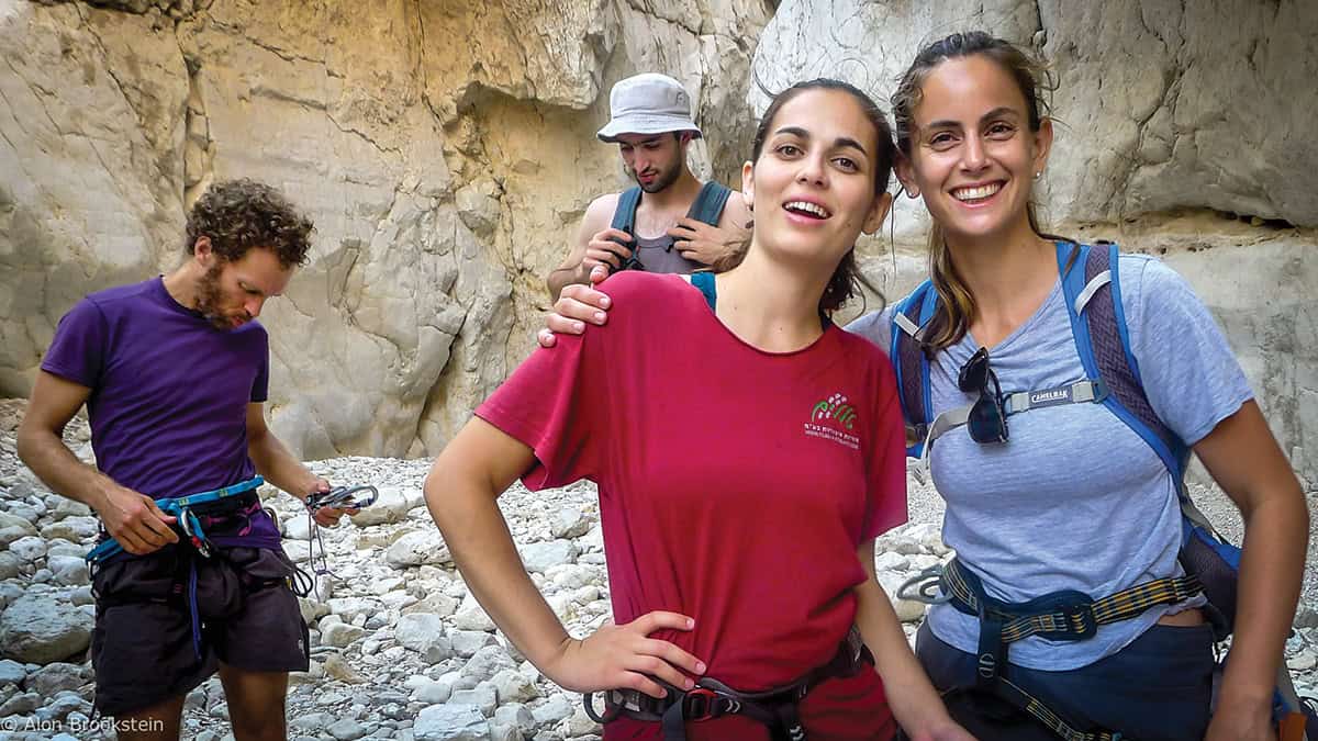
Adi Davis (right) and Yarden Roman at Nahal Rahaf (Photo: Alon Brookstein)
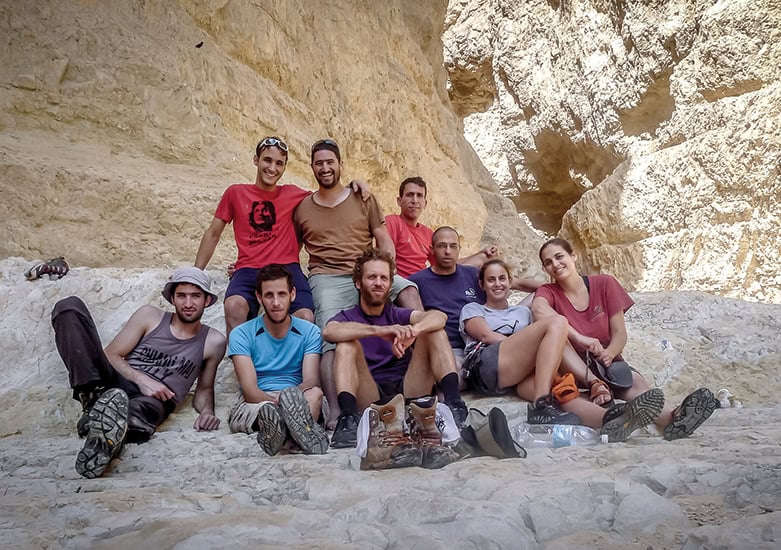
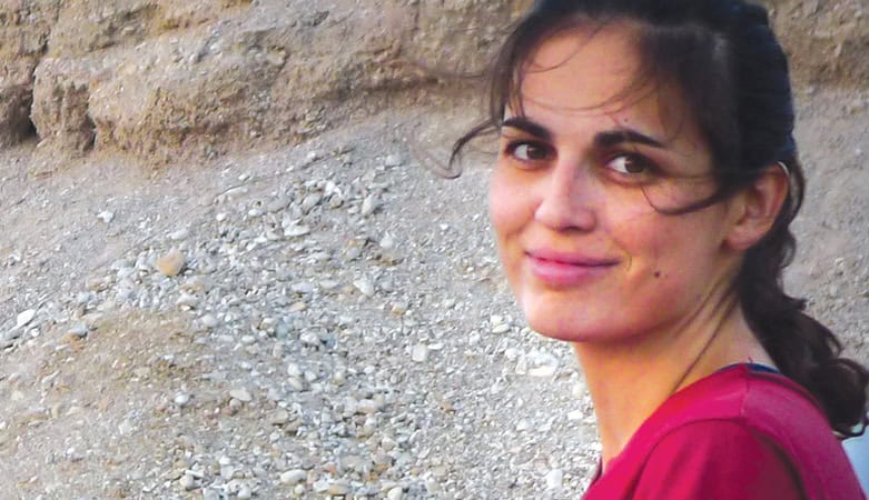
My niece Yarden, the daughter of my brother Jony, was taken hostage by Hamas from Kibbutz Be’eri to Gaza on Saturday, October 7, 2023. She was an avid rock climber from an early age, well known in the small community of Israeli rock־climbing adventurers. Together with the Israel Climbers’ Association, we have put together a photo gallery of some of the climbing adventures in Israel – waiting for the day she returns to climb again
Yadin Roman
From ERETZ magazine – issue no. 187 – December 2023
My niece, Yarden Roman־Gat, was kidnapped at Kibbutz Be’eri on Saturday morning, October 7, together with her three־year־old daughter Geffen and her husband Alon. They were bundled into a small car by four terrorists that sped towards the border fence with Gaza. Near the fence, the terrorists spotted an Israeli tank and stopped for a minute. With Geffen in her arms, Yarden and Alon, in a split־second decision, jumped out of the car and began to run up a small ravine. The terrorists fired after them with automatic weapons and gave chase. After running for about 200 yards, with bullets zipping around them, Yarden handed Geffen over to Alon and told him to run as quickly as he could. Yarden took off in a different direction and took refuge from the bullets behind a tree, directing the fire and the terrorists toward her.
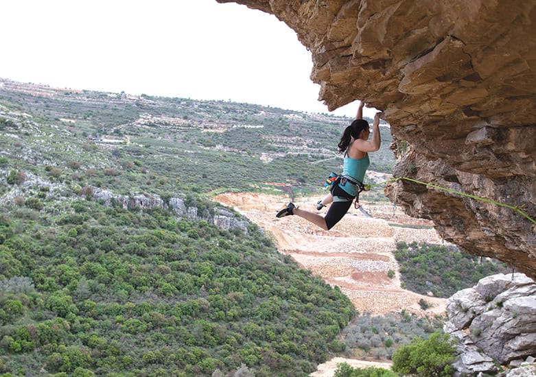
Inbal Katzenelson climbing Gita Cliff (Photo: Diego Rosman)
Alon, with Geffen, found a niche in the ground and scrambled into it, concealing their whereabouts with branches and bushes. For 12 hours, Alon and Geffen hid in their makeshift shelter with terrorists all around searching for them. The following day, Alon, with Geffen in his hands, made his way to the Kibbutz, where fighting between the terrorists and the army was still going on. Circumventing the Kibbutz, he reached the main road and the Israeli forces. The next day, Gili, Yarden’s brother, went to where she had last been seen. He scoured the area for four days with volunteers from the armed forces, including Bedouin trackers. No trace of Yarden was found. She had been retaken by her captors and taken to Gaza.
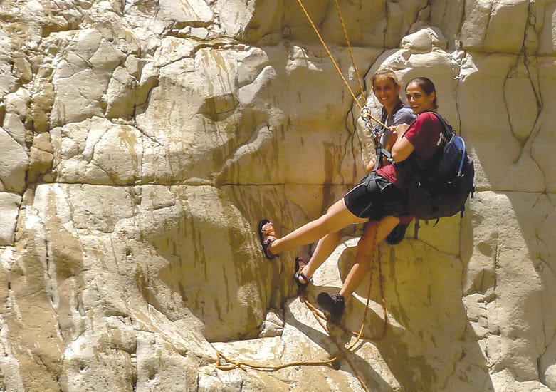
Yarden Roman (left) and Adi Davis (right) rappelling in Nahal Rahaf (Photo: Alon Brookstein)
Since she was a small child, Yarden loved the outdoors. Hiking and camping trips were her favorite pastime. Above all, she loved climbing. Rocks, cliffs, boulders, climbing walls, the lot. She was a member of her hometown climbing club, won a few trophies, and scaled many of the highest cliffs in the country. She met her future husband, Alon, at one of these climbing meets. Three months after they met, Yarden and Alon set out on a trip to the United States to reach some of the better־known sport־climbing sites. After Geffen was born, adventures had to be toned down a little, but the love for the sport remained. They planned to visit Australia and New Zealand to reach well-known rock climbing sites.
Valeri Kremer climbing the cliff in Ein Prat (Photo: Gilad Furst)
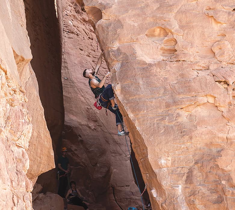
Rock climbing in Israel is a young sport. However, it is gaining in popularity. In 2019, the Israel Climbers’ Association was founded to serve the approximately 15,000 climbing enthusiasts in the country. Rotem Jacobs, one of the Association’s directors, knows Yarden well. Three decades ago, the small group of cliff lovers met repeatedly in competitions, events, and on the cliffs. “In a small country like Israel,” says Jacobs, “there aren’t many authorized climbing sites. The most challenging is at Ein Prat, in the Judean Desert. Others are at Beit Ariyeh, the Timna Park in the southern Arava Valley – where the management of the park is encouraging the development of this challenging sport – sites in the Judean Mountains, in the Ramim cliff overlooking Kiryat Shemona, in the Carmel and more. One of the tasks of the Association is to add more official climbing sites around Israel.”
The climbing group in Kochav Yair hanging in Nahal Rahaf (Photo: Alon Brookstein)
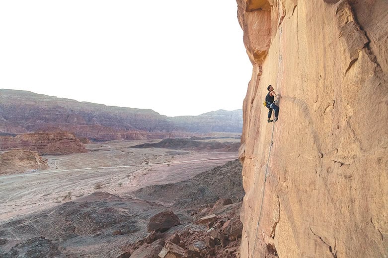
Timna Park is one of Israel’s most adventurous and challenging climbing sites. The Timna Valley is a horseshoe־shaped basin surrounded by high Nubian Sandstone cliffs in the southern Arava Valley. The Valley is famous for its many copper veins, one of the first places in the world where copper was mined. Archaeological excavations in the Valley have ascertained that copper mining activities started during the 5th and 6th millennia BCE and have continued throughout the ages. Dozens of copper mines and mining tunnels have been located in the Valley, with remnants of mining sites initially attributed to the Edomites and King Solomon (hence the sandstone pillars known as Solomon’s Pillars).
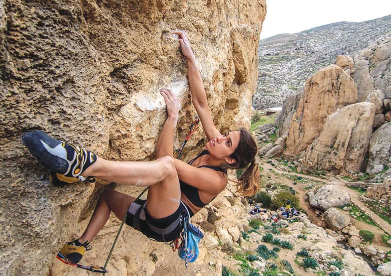
Mor Sapir climbing in Timna Park (Photo: Diego Rosman)
In Timna Park, over 85 climbing sites have been marked, 10־50meters high, encompassing all the different styles of sport climbing. The majority scale the smooth, straight sandstone cliffs; a few others scramble up single־standing boulders along the edges of the cliff face. Climbers from around Israel volunteered to help with this article, sending us information and photographs of climbing events. The Climbers’ Association is planning a climbing event, open to the public, in honor of Yarden and as part of the efforts to keep the struggle to release all the hostages foremost in the public eye.
Yosi Ben Yosef climbing in Timna Park (Photo: Diego Rosman)
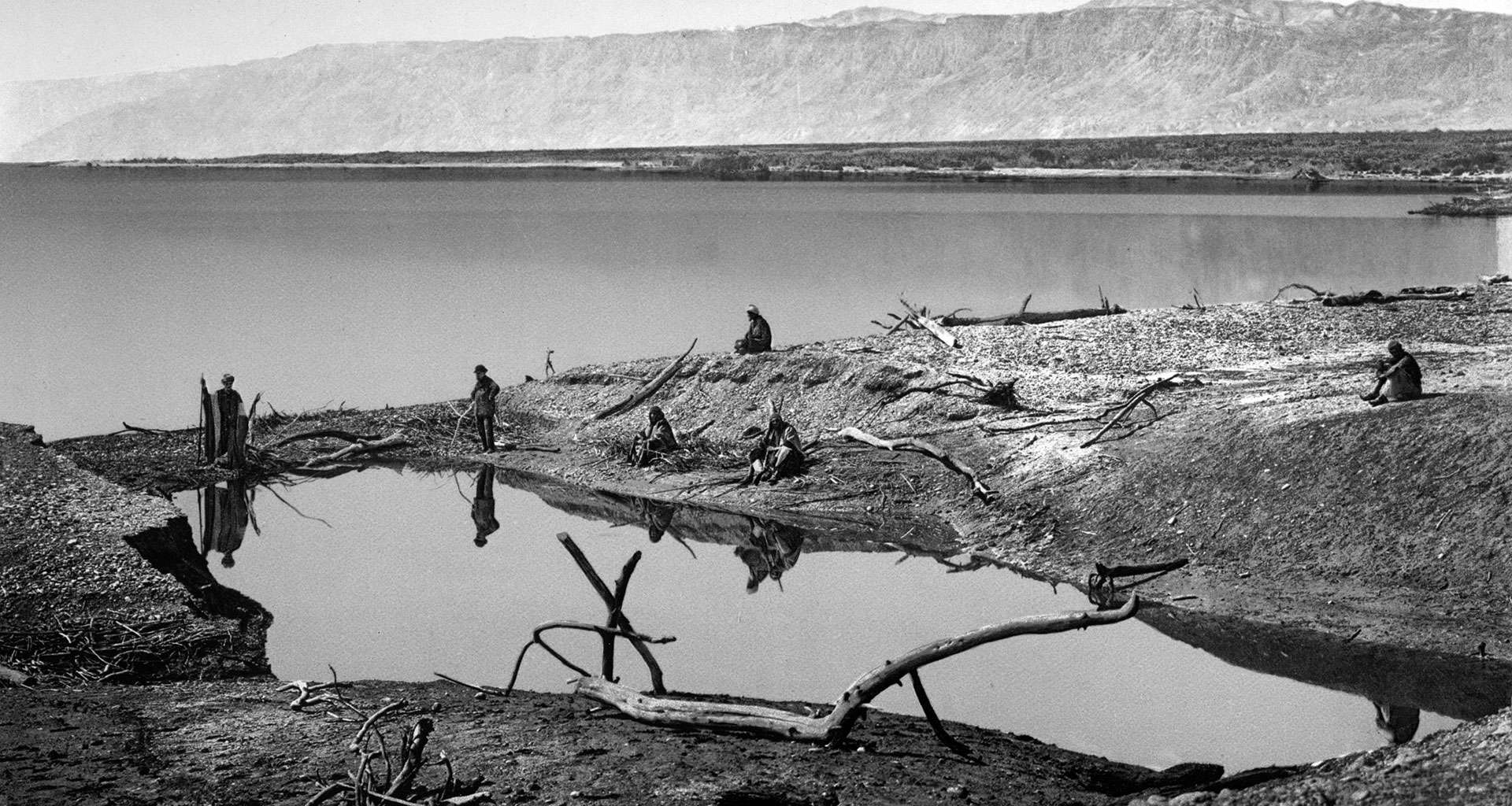
It is difficult to pinpoint when the Dead Sea and its historic sites were forgotten, but in the Middle Ages, major effort was required to visit the Dead Sea region, whose paths were unknown and its few places of settlement difficult to reach. In the early nineteenth century, when modern geographical research began, very few dared to travel to the Dead Sea. The Ottoman Empire, which had ruled this region since the sixteenth century, was in such disarray that, in 1831, the governor of Egypt, Muhammad Ali, gained control of the Land of Israel, holding it for nine years. The Bedouin tribes that roamed the deserts of the Middle East did not accept the overlordship of either the sultan in Istanbul or the Egyptian pasha in Cairo. Even if an adventurous explorer managed to obtain a permit from the sultan to visit a faraway corner of the empire such as the Dead Sea, the Bedouins showed no regard for this official sanction. At the very least, they demanded protection and passage money – each tribe in its own territory, according to the intertribal rivalries and wars over living space, grazing rights, and water sources.
It was impossible for a foreigner, especially a European, to just venture into the deserts of the Ottoman Empire. The first European travelers who attempted to navigate these routes learned to speak Arabic, versed themselves in Moslem customs, and dressed as Arabs, recording their impressions of this unknown world only when no prying eyes could watch. Some lost their lives in the attempt to explore these forbidden lands; they were murdered, died of unfamiliar diseases, lost their way, or dehydrated in the desert sun.
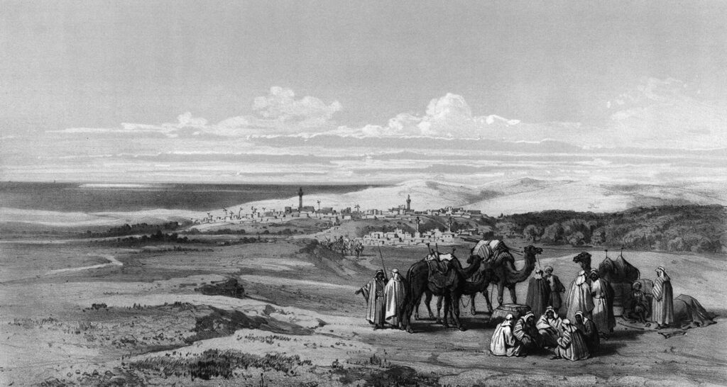
A lithograph of a convoy of travelers in Gaza from Charles William Meredith van de Velde’s travels in the Holy Land in the 1850s.
The first modern traveler to circumvent the Dead Sea was a German explorer, Ulrich Jasper Seetzen. Studying medicine in Gottingen, Germany (he became a doctor in 1789), Seetzen was exposed to a new approach in geography: employing travel observations and collections of flora, fauna, and artifacts to understand the world. It was one of his classmates, Alexander von Humboldt, the founder of modern geography, who developed the concept of travel in the field as the basis for the expansion of scientific knowledge. These new ideas profoundly influenced Seetzen; around 1799, he decided to devote himself to the discovery and research of the African continent. He lined up a few sponsors and contacted a few museums, promising to send them the specimens that he intended to collect during his travels. With the financial support for his mission secured, Seetzen set out for Africa, starting with Syria, which he reached in 1804. His first stop was Aleppo, where he improved his knowledge of Arabic and Moslem customs. In April 1805, he arrived in Damascus, from where he set out on a number of fact-finding trips to the Hauran and the Jordan Rift Valley. During his travels, he presented himself as a Moslem doctor by the name of Mousa al-Hakim (Mousa the doctor).
“I let my beard grow, dressed myself in a half-Turkish, half-Arab costume, took on an Arabic name, Mousa, and equipped myself with some medicines,” he reports.
The title of his second travel diary reveals the huge scope of his early travels: Travels from Aleppo to Damascus, and from there to the Hauran, the Lebanon and Anti-Lebanon, the Leja, Hermon, Golan, al-Ghor, Jabel Ajlon, el Balaka, and around the Dead Sea to Mount Hermon and Jerusalem. Seetzen collected information obsessively. He wrote down the names of all the villages along his way that he did not manage to get to, made a list of all the riverbeds around the city of Kerak, copied over 150 Greek inscriptions that he encountered along the way, compiled a list of the types of Arabian race horses, meticulously recorded the mineral composition of rocks, mentioned the names of all the animals that he saw, and gathered countless samples of flora.
On April 9, 1807, Seetzen arrived at Saint Catherine’s Monastery in the Sinai. He left behind a letter written in French, hanging it on the wall of the monastery’s guestroom: an amazing catalogue of unexplored sites that Seetzen was the first European to visit. Five years later, Swiss traveler John Lewis Burkhardt, the first European to reach Petra, copied it: “U. J. Seetzen, called Mousa, a German traveller, M.D. and recorder (Assesseur) of the College of H. M. the Emperor of all the Russias in the Seigneurie of Jever in Germany, came to visit the Convent of St. Catherine, the Mountains of Horeb, Moses and St. Catherine etc.; after having traversed all the ancient Eastern provinces of Palestine, namely: Batanea, Decapolis, Gileaditis, Ammonitis, Amorrhitis, and Moabitis, as far as the frontiers of Gebelene (Idumea) and after having twice made the tour of the Dead Sea, and having crossed the desert of Arabia Petraea, between the town of Hebron and Mt. Sinai, after a sojourn of ten days he continued his journey to the town of Suez” (Burkhardt, Travels in Syria and the Holy Land, 1822).
From Suez, Seetzen continued to Cairo. In March 1809, he sailed to Jidda in the Arabian Peninsula, bent on visiting the holy cities of Islam before continuing onward to the main area of his research: Africa. However, when he arrived in Mecca, he aroused the suspicions of the imam, who had him poisoned. Seetzen died in September 1811. His journals and notes were published 50 years later. When they finally were presented to the public, it turned out that they still were the most accurate descriptions of the areas he had visited. A sketch that Seetzen made of the Dead Sea area became the base for the first modern map of the Dead Sea.
Seetzen was not only the first modern explorer to circumvent the Dead Sea, but also the first to put Masada on the map, under the name “Szebby,” which was an Arabic distortion of the name “Saba,” that is, Masada.
A decade after Seetzen’s journey, two officers from the British Royal Navy, Charles Leonard Irby and James Mangles, set out on a brief tour of Europe and the Middle East. The tour that was planned to last for a few short months turned into a fascinating four-year adventure.
Following a comprehensive visit to the antiquities of Egypt, the two set out on camels to cross the Sinai desert to reach Jaffa. From there, they traveled north along the coast to Caesarea, Haifa, Acre, and Rosh Hanikra. They toured Lebanon; visited Tripoli, Homs, Aleppo, and Damascus; traveled through the Hauran and the Golan; descended to the Hula Valley; crossed the bridge of the Daughters of Jacob; visited Banias and the Hula Lake; ascended to Safed; passed through Tiberias, Zemah, Hamat Gader, and Beit She’an; and finally recrossed the Jordan to visit Jarash and Salt in Transjordan.
In May 1818, they planned to circumvent the Dead Sea and from there travel to Petra, in accordance with the wishes of their traveling companion and sponsor, Mr. Bankes. With typical English understatement, they explain the difficulties of undertaking this voyage: “as the only two Europeans who had ever been at… Petra [Seetzen and Burkhardt] are both dead…. performed this trip alone and in disguise… and made all their observations by stealth, which necessarily rendered their remarks very brief and cursory” (Charles Leonard Irby and James Mangles, Travels in Egypt and Nubia, Syria, and Asia Minor; During the Years 1817 & 1818). They decided to set out disguised as Moslems; Irby became Abdullah and Mangles, Hassan. After many difficulties, they finally made it to Petra. The return trip was around the southern edge of the Dead Sea, which resulted in a fascinating description of the vegetation and landscape of the Dead Sea shore and the fertile Zohar Valley.
While riding back to Jerusalem, they reported on a phenomena that baffled Dead Sea experts for many decades. As they descended from Kerak to the eastern shore of the Dead Sea, they encountered a small caravan of horses and mules on their way to Jerusalem. Irby and Mangles overtook the caravan and on reaching the shore of the Dead Sea, turned south in order to ride around the southern edge and come up again on the other (western) side. As they rode up the western side, they suddenly saw, in the distance, the small caravan walking in front of them. The caravan, they reported, had crossed the sea on a shallow ford in its center. This enigmatic ford never was seen again, but inspired much speculation. If it had existed, then it would have been one of the reasons for the location of Masada. This short cut across the Dead Sea is exactly opposite, and in full sight of, the fortress. It would have been the shortest route between the oasis of Ein Gedi along the western shores of the sea and the fertile plains around Kerak on the other side of the sea and the shortest route from Jerusalem to the Nabatean Kingdom.
Seventeen years passed before the next chapter in the rediscovery of the Dead Sea area: the sad sojourn on the sea of Christopher Costigan, who set out in a small boat with a Maltese servant to sail on the Dead Sea. The 25-year-old Irishman decided to sail down the Jordan River from the Sea of Galilee to the Dead Sea and continue to sail around its coast. Costigan bought a boat in Beirut, transferred it to Acre, and then transported it on camelback to the Sea of Galilee. He arrived there at the height of summer, in July 1835, but the Jordan, then a mighty river, still had a strong, turbulent current that overturned Costigan’s small boat repeatedly. He did not give up and instead hired camels to carry the boat to Jericho and the Dead Sea. A few days after he and his servant arrived in Jericho, he sailed the boat on the waters of the Dead Sea. For the next eight days, Costigan circumvented the shores, measuring the depth of the waters at different points. At night, he slept on shore. At four points along the shores, the two sailors saw ancient ruins, one of which they identified as the ruins of Gomorrah. On the sixth day of their voyage, they ran out of water. The next day, Costigan started to drink Dead Sea water and on the eighth day, they barely managed to get back to the northern shore. The Maltese servant set out to seek help and left Costigan on the beach lying under the boat, where a group of Bedouins discovered him and took him and the boat to Jericho. The Maltese, in the meantime, made it to Jerusalem, where he recruited the aid of an European missionary, John Nicolayson. The missionary rushed to Jericho and found Costigan completely dehydrated. After harnessing a makeshift stretcher for Costigan to a horse, the missionary managed to transport him to Jerusalem, where a doctor eventually revived him. By then, however, he had contracted malaria, which claimed his life a few days later. He was buried in Jerusalem, in the Protestant cemetery on Mount Zion.
Two years after Costigan’s tragic attempt to sail the Dead Sea, two additional Englishmen, G. H. Moore and W. G. Beke, set out to make trigonometric measures on the Dead Sea. The two bought a boat in Beirut, shipped it to Jaffa, and transported it to Jericho via Jerusalem. They only managed to complete some of the tasks that they took upon themselves because their Bedouin guides were scared of entering the territory of the hostile tribes around the sea. Even so, they made some interesting discoveries, finding that the boiling point of water is much higher than normal at the Dead Sea. This led them to the conclusion that the Dead Sea is substantially lower than sea level. Barometers already had been invented by then, but they were too cumbersome to take along to the desert. It was only in 1841 that the real level of the Dead Sea finally was measured in a series of horizontal measurements taken with a level. An officer of the British Royal Engineers, J. F. A. Symonds, spent 10 weeks measuring the difference in elevation between the Mediterranean Sea at Jaffa and Jerusalem and then went on to measure the difference in elevation between Jerusalem and the Dead Sea. His result – minus 1,311 feet, about 437 meters below sea level – was very close to the measurement that officers of the British Geographic Society obtained with a barometer a few decades later. Once that was solved, explorers moved on to the challenge of measuring the difference in height between the Sea of Galilee and the Dead Sea, which of course influenced the flow of the Jordan River, a topic which held their attention throughout the 1840s.
In 1847, Lt. Thomas Molyneux, of HMS Spartan, and three volunteers were sent to sail down the Jordan from the Sea of Galilee in order to measure the difference in elevation. None of the four had any experience with Bedouins or the desert. Molyneux set out at the end of August for Acre. From there, he transferred his boat on camelback to Tiberias, sailing from there into the Jordan River. Right from the beginning, Molyneux had trouble with the Bedouins. He refused to pay passage money and then insulted them by finally offering too meager a sum accompanied by a display of his arsenal of arms. Very soon, the four discovered that they could not continue on the serpentine river and so they continued on shore, where they discovered that they were amidst a large number of Bedouin encampments. Molyneux sent his companions to try to navigate the river again, but they were attacked by Bedouins who stole everything on board the boat. When the boat failed to arrive at the agreed-upon meeting point, Molyneux set out to look for his men, found the empty boat, and made a dash for Jericho and Jerusalem, where he put together a search party that was unable to find his crew.
Molyneux did not give up. He recruited a new crew: a guide from Tiberias and a young Greek from Jerusalem. As evening fell, he set sail on the Dead Sea. Molyneux’s boat was equipped with only two oars and his crew members did not have the faintest idea of how to maneuver the small vessel. After two stormy nights at sea, Molyneux realized that they would not make it to the peninsula in the middle of the eastern shore and decided to return to Jericho. After a night and a day of hard rowing, the three managed to return to the northern shore. Molyneux loaded the boat on camels and managed to return to the HMS Spartan, where he discovered his three original companions, safe and sound. They had managed to make their way back to the ship. Molyneux, like Costigan, came down with malaria, and died in November 1847, on board his ship in Tripoli or Beirut.
In April 1948, Gesher was the first settlement that had to face the attack of a regular army – the Jordanian Arab Legion. In May 1948, with Israel’s declaration of independence, the settlement was in the eye of the Iraqi invasion.
Following the siege, Gesher was totally destroyed, but its members held out until the withdrawal of the enemy. Upon the conclusion of the war, the settlement moved to a new site.
Today, a museum operates in the historic site. It illustrates life at Gesher in its early days through the old buildings, exhibits, and an audiovisual presentation.
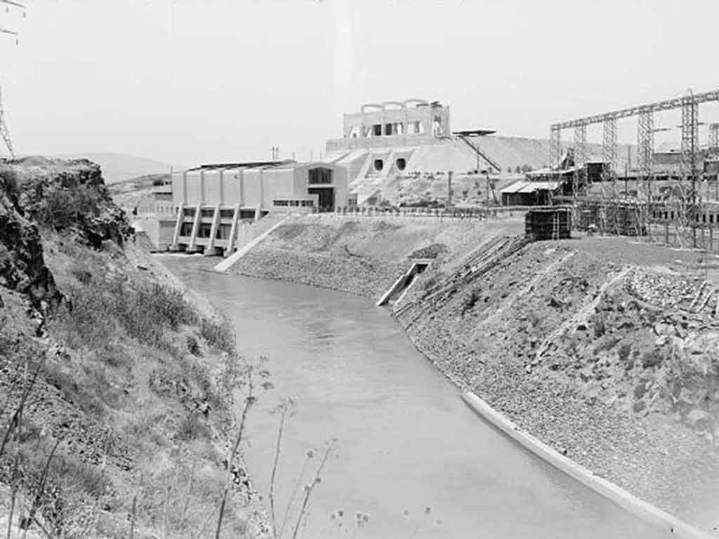
The site also includes the recently inaugurated Gaon Hayarden Promenade, whose circular route overlooks the Jordan River and the Naharayim power station. In the heart of the promenade is the Bridges Lookout, with a view of the three historic bridges that used to cross the Jordan.
Also at the Gesher site: a model illustrating the method of operation of the Naharayim power station, the remains of a caravansary from the Mameluke period, and a British police fortress. One of the locomotives that was used in the construction of Naharayim was completely renovated and repainted, and can be operated for a short trip around the site. Directions: Kibbutz Gesher. Access from Road No. 90, opposite the entrance to the kibbutz.
Castel National Park, Mevasseret Zion
Castel National Park is located on the ruins of a Crusader castle and an Arab village. In the War of Independence, the site was an important army post, which overlooked the main road to Jerusalem, and bloody battles were fought for control of the Castel. Reconstructed bunkers and trenches can be seen at the site, complete with explanatory signs.
From the top of the hill there is a breathtaking view of the Judean Mountains.
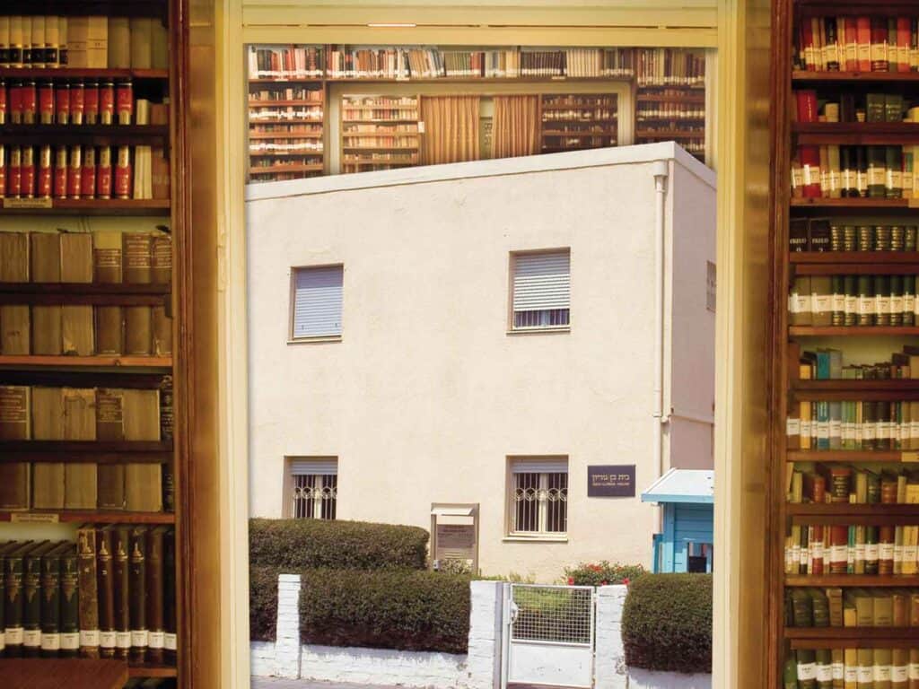
Ben-Gurion House (Courtesy of Ben-Gurion House Museum)
Ben-Gurion House, Tel Aviv
This building was the home of David and Paula Ben-Gurion until they moved to Sde Boker. After their move, they would stay here on their visits to Tel Aviv. Ben-Gurion bequeathed the house to the State of Israel. The house contains the same furnishings, decorations, and household objects it had when the Ben-Gurions lived there, in addition to exhibits. It was opened to visitors in 1974.
In 1981, the building to the north, the home of labor leader Hillel Cohen, was made part of the museum compound, in accordance with Cohen’s will. This building houses a permanent display on Ben-Gurion and his heritage and classrooms that are used for lectures and seminars on the Jewish people, Zionism, and society.
The museum offers activities for children and youth and has a 20-minute film.
Ben-Gurion’s library is open to the public (by appointment).
Palmach Museum, Tel Aviv
This museum features a sophisticated presentation on the Palmach (an acronym for Plugot Hamahatz or Striking Force), the military branch of the Haganah underground organization.
It shows the Palmach’s heritage and role in the War of Independence and the establishment of the State of Israel.
Visitors join a group of young people from the time they enlist in the Palmach, shortly after its establishment, until the end of Israel’s War of Independence. Their fascinating personal story, a three-dimensional display, and special effects bring the documentary material about this period to life.
The tour of the museum begins and concludes in a memorial hall for fallen Palmach fighters.
The museum also hosts temporary exhibits. Additional educational activities, led by museum guides, are available if arranged in advance. The Palmach Museum is part of the Museums Unit of the Ministry of Defense.
Outpost Facing Gaza, Kibbutz Sa’ad
This museum is located in the only building that survived after Kibbutz Sa’ad came under heavy attack in Israel’s War of Independence.
The site is devoted to a depiction of the history of the three religious kibbutzim in the area. On the ground floor of the museum is an exhibit of photographs from Sa’ad’s experience in the War of Independence and telegrams describing events in the time of the war.
The exhibit shows the suffering of the fighters who had to spend day and night in the trenches.
On the second floor, an audiovisual presentation is screened; it deals with the atmosphere in the Land of Israel in the time of the war and other topics. The building’s roof affords a nice view of the entire Gaza Strip.
Yad L’Isha Halochemet, Old Nitzanim
The battle of Nitzanim, whose fallen included three female fighters, inspired the creation of Yad L’Isha Halochemet, a monument dedicated to the women who lost their lives in the battle and to female fighters in all of Israel’s wars.
The monument is part of the Old Nitzanim site, which features an audiovisual presentation on Nitzanim’s heroism in Israel’s War of Independence and on the female fighters.
Visitors can also see “The Palace” – an old Arab orchard house in which the defenders of Nitzanim bastioned themselves, reconstructed positions from 1948, and other monuments to fighters.
The site offers a variety of guided tours in the adjacent Dune Park.
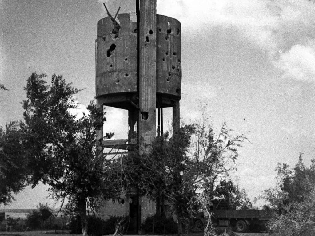
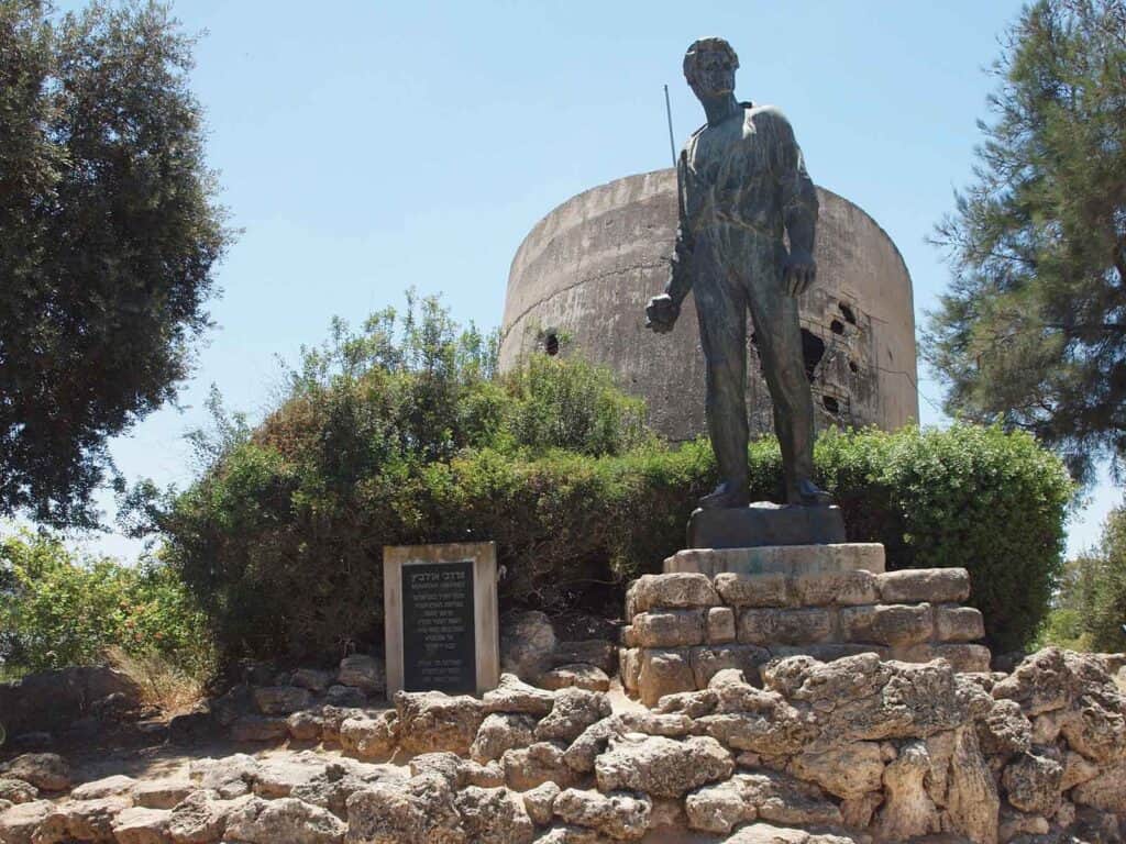
War of Independence. Damages in Kibbutz Negba at water tower after the Egyptian soldiers left (GPO)
The Open Museum, Kibbutz Negba
A bronze monument sculpted by Natan Rapaport depicts three Negev defenders. Beside it is the Open Museum, featuring the water tower that was a major lookout point in Israel’s War of Independence and was blown up by Egyptian planes. There are also an Egyptian tank, the first tractor on Kibbutz Negba, and Negba’s original tower and stockade site (the structures were put up overnight to create settlements before the British could stop them).
Givati Brigade House, Yoav Fortress, Lakhish
This site played an important role in Israel’s War of Independence. The museum focuses on the deeds of the brigade in 1948 and also on the new Givati Brigade.
It offers a selection of videotapes, and the memorial room has a wall with the names of the fallen of the brigade and a computerized system that provides information about them.
In addition, there is a room with Israeli and Egyptian weapons; exhibits of Israeli and Egyptian military vehicles; a lookout tower; an amphitheater for various gatherings; a library, and an instructional center.
The museum offers guided tours to Givati sites in the area.
Ben-Gurion’s Hut,Kibbutz Sde Boker
The hut that was the desert home of David Ben-Gurion, first prime minister of Israel, and his wife Paula has remained as Ben-Gurion left it when he died (1973), as he requested in his will.
The area around the hut is well tended. In addition, approach paths have been paved, and plazas for presenting explanations have been built. Sayings from David Ben-Gurion’s philosophy and pictures illustrating early life on Kibbutz Sde Boker have been incorporated in the area.
In the heart of the hut is Ben-Gurion’s workroom, containing part of his library. In this room, he wrote his many books and articles.
In the next hut, which was used by his bodyguards, is an exhibit showing David Ben-Gurion’s special attachment to the Negev.
Yad Mordechai Museum (Heidi Gleit)
Yad Mordechai Museum, Kibbutz Yad Mordechai
This museum is devoted to the Holocaust, the partisan battles in World War II, and the fighting in the area of Yad Mordechai during Israel’s War of Independence.
The section depicting the Holocaust chronicles the rise of the Nazis to power, the life of the Jews in the ghettos, the Warsaw Ghetto uprising, and the path to the crematoria of Auschwitz.
The museum narrates the resistance of companies of Jewish partisans in Nazi-occupied territory, the clandestine immigration to the Land of Israel, the establishment of 11 settlement points in the Negev (1946), the battles against the Egyptian invaders, and mainly the bitter fighting for Kibbutz Yad Mordechai.
Beside the museum is a monument to Mordechai Anilewicz, leader of the Warsaw Ghetto uprising and the person after whom the kibbutz is named.
The scene of the battle for Yad Mordechai is re-created in the spot where it took place.
Thirty years after its inauguration and with some modifications, the nearly one thousand kilometer trail is an experience not to be missed. Yes, it’s a 45-day hike that some Israelis finish in one haul. Most people will do it in segments. Families set out to hike the trails 52 segments in a year of weekends (it has become very popular as a bar-bat mitzvah year project), others hike it in three-day segments over a long time (the last group that I led on the trail did it in 5 two day meetings a year over six years).
There is no better way to get to know the landscapes of Israel and its people than by hiking the trail. So the next time you’re here, take a few days on the trail. It is clearly marked, and you don’t have to be an expert hiker. But, once you finish, it is an experience that your grandchildren will talk about to their children, telling them stories of that time “when our parents hiked the Israel Trail.”
Israel is a land of varied landscapes and a bewildering assortment of historic, and ancient sites. But, it is no Italy, or Egypt. There are no towering cathedrals, no ostentatious palaces, no pillared temples. Israel is a land of soul and feeling. To really enjoy it you need an interpreter, to bring to life the astounding essence of this country.
These interpreters are the Israeli tour guides – the madrichim; the mentors who fill with meaning the ruins and sites.
For the past two-years the madrichim have been out of work – waiting for the day when tourism will resume. Hopefully we will find the way to preserve the profession, and not discover tomorrow that we cannot give our visitors the experience that is Israel.
Yadin Roman
Jacob Shoshan
I am looking forward to welcoming you back. Enjoy the intriguing mosaic of creeds, cultures, flavors, and scents that make up this country. We’d love to show you many new locations – Anu, the Jewish Museum, Innovation Centers, agriculture technology, artifacts discovered in archaeological digs.
I miss the sparkle in my tourists’ eyes at the end of a day in Jerusalem’s Old City, always an intense experience. No structure or edifice in Jerusalem will take your breath away, but the text that enlightens these sites is the biggest story ever told.
My dear friends. I miss you. The comradeship on the bus, your love of everything to be seen in this country. Miss our walking tours, hikes in the desert and mountains, and all that fills me with love and passion for helping you visit this country.
Waiting to have you back and show you around on a life-altering experience. Jerusalem, Tel Aviv, The Galilee, The Negev Desert, The Jordan River. Israel is a treasure trove of historical sites – with unique Arts and Fashions scenes, a trendsetting culinary haven, and a multi-cultural spectrum.
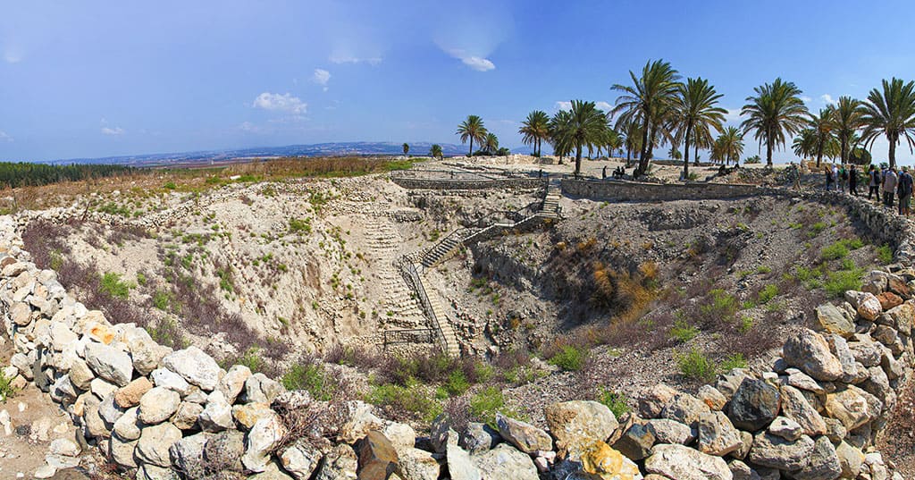
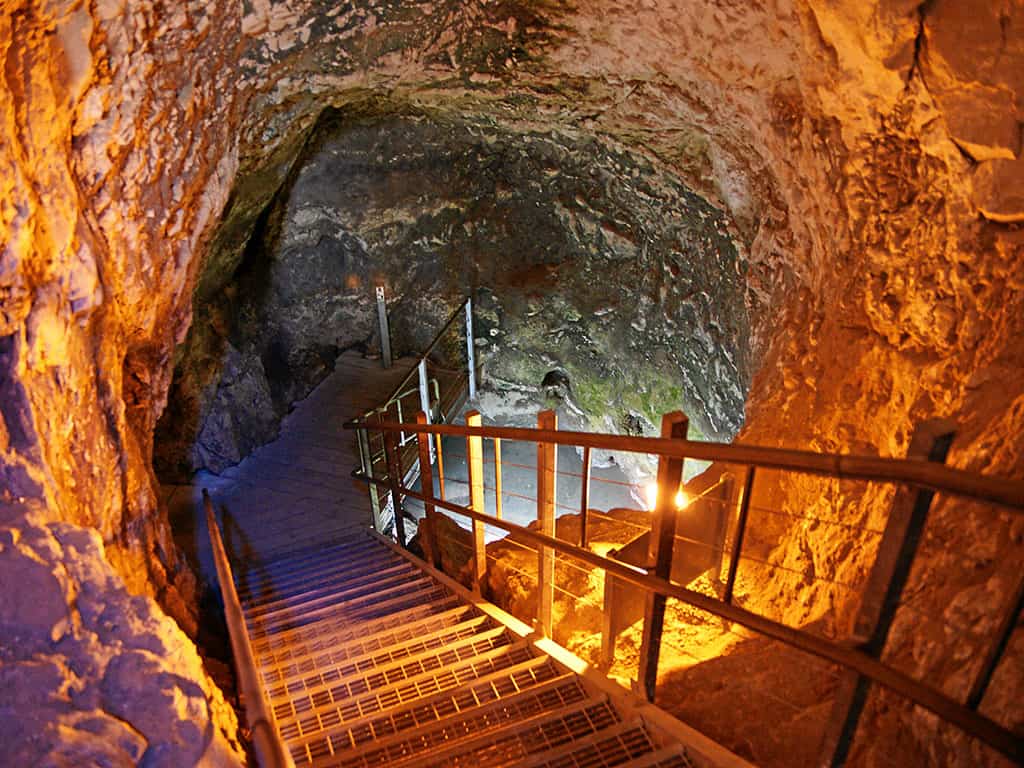
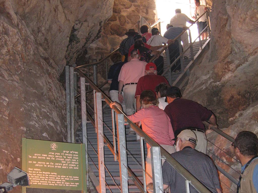
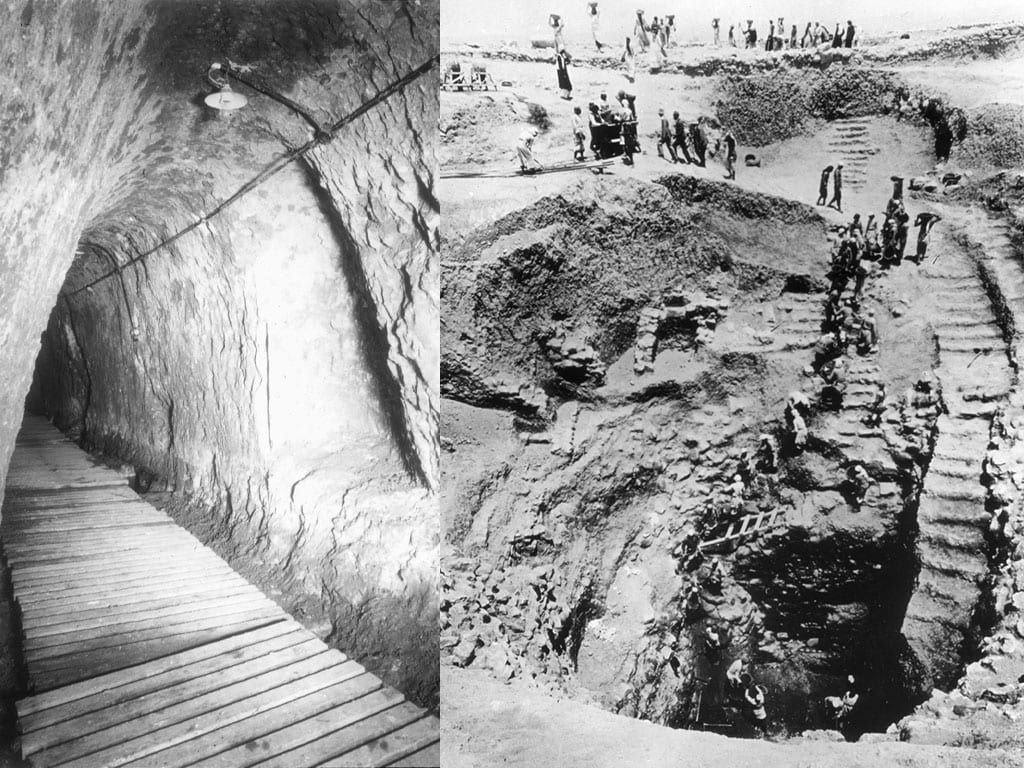
The most impressive of the ancient remains at Megiddo is the water system with its grand shaft and tunnel. The system was discovered by the Chicago Expedition in a complex dig that involved dozens of workers and the removal of massive amounts of earth. Once the system was cleared a concrete roof was built over the entrance to the shaft and steps were built to make it possible to descend to the tunnel.
(Mboesch)
Exit from the water system. (Talmoryair)
(Sopotnicki)
(IVAN VIEITO GARCIA)
Megiddo had two sources of water. Ein Megiddo (Ein el Kobi) in the east, and a second water source in the west. The second water source emanated from a cavern that over the years was deepened by the inhabitants of Megiddo to concentrate a larger flow of water. A series of steps was built leading down from the western side of the tel into the cavern and the water. Reaching the western water source from the tel entailed walking out of the gate in the north eastern part of the city and then around the northern walls to the spring. In the 9th century BCE, during the time of the Omrides, a stepped gallery which allowed access from the western side of the tel straight down to the entrance of the cavern was built.
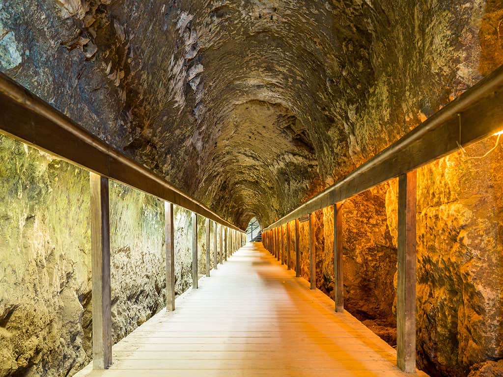
The water system itself was built in the 8th century BCE during the time of Yoash and Jeroboam the Second. It involved digging an open pit through the ancient layers on the western side of the tel, all the way down to bedrock. Here a diagonal shaft was hewn in the rock, down what was presumed to be the water level – probably marked by a clay layer that caught the water seeping through the limestone rocks, the catchment area of the spring. Then a 52-meter long tunnel was hewn through the rock all the way to the spring. Finding the clay layer was a complex operation – but figuring out in what direction to dig was a more complex and difficult task.
Once the tunnel reached the spring a second stage was embarked upon. The tunnel was deepened and extended to the bottom of the outside pier, so that the water could flow from the spring along the tunnel to the area of the shaft, and from there it was drawn up into the city. Once this was completed the outside entrance to the spring was blocked so that the only access to the water was from inside the city.
The water level that collects in the pool of the spring fluctuates according to the amount of rainfall every year and during the rainy season. Even today after heavy rains the waters from the spring will flood the tunnel keeping it closed for weeks on end.
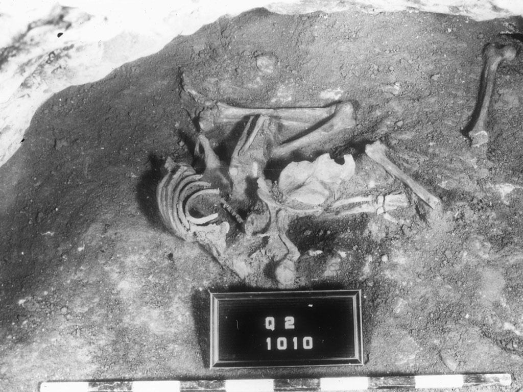
Use of the water system probably ceased with the Assyrian conquest. We don’t know exactly how this happened, but a gruesome find when the water system was unearthed may provide us with a clue. On the inside of the blocked up original entrance to the spring a skeleton was found – it may have been the soldier who was posted to guard the entrance and who died at his post.
Skeleton discovered at the blocked entrance to the spring. Perhaps the guard assigned to guard the water system on Megiddo’s final hour. (Oriental Institute, Chicago)
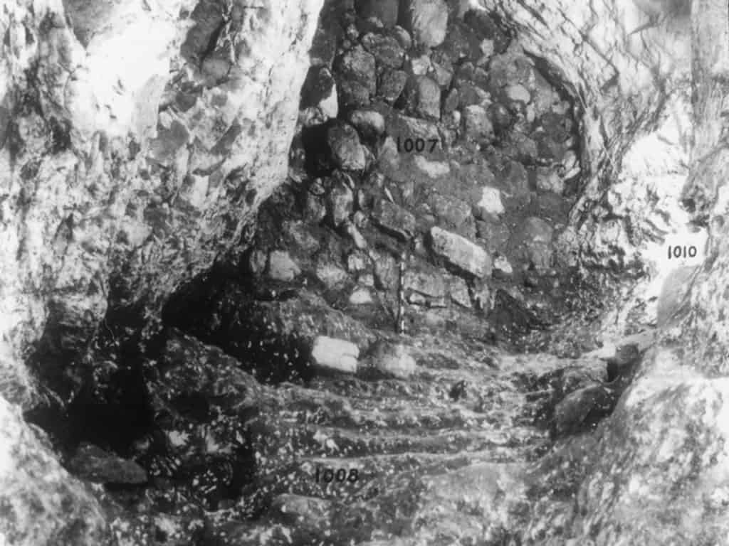
The blocked outside entrance to the spring. (Oriental Institute, Chicago)
Left: The tunnel in the 1930s. (Oriental Institute, Chicago)
Right: Unearthing the water system shaft. Notice the original steps. (Oriental Institute, Chicago)